 Filter: Categories of Wisconsin Historical Images
Filter: Subject of Ocean
Filter: Categories of Wisconsin Historical Images
Filter: Subject of Ocean
| Date: | 1912 |
|---|---|
| Description: | Calbraith Perry Rodgers, with a cigar characteristically clenched in his jaw, was the first man to fly across the United States. He undertook this flight i... |
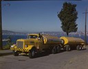
| Date: | 1951 |
|---|---|
| Description: | Color photograph of an International LD-400 series tanker truck owned by Eastern Washington Transports, Inc., on a road near the Port of Seattle. |

| Date: | 1938 |
|---|---|
| Description: | A colorful pictorial map of Australia, featured on the front and back cover of a special Australian edition of International Trail. |
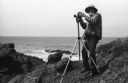
| Date: | 1968 |
|---|---|
| Description: | Photographer Ansel Adams mounting his Hasselblad camera onto the tripod on a rocky shore near or at Point Lobos. |

| Date: | 1968 |
|---|---|
| Description: | Photographer Ansel Adams setting up his camera in a wooded waterfront area near Point Lobos. |
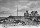
| Date: | |
|---|---|
| Description: | Eastern Point Lighthouse at "Mother Ann" and residence on rocky point, Gloucester, Massachusetts. Mother Ann is a rocky cliff at the far south end of Easte... |

| Date: | 1798 |
|---|---|
| Description: | Uncolored. No scale. One of the earliest maps to show the proposed division of the northwest territory into states. |

| Date: | 1850 |
|---|---|
| Description: | [... through northern United States from New York to Minnesota]. Lithography by T. Sinclair. From Perrault papers, Lucien S. Hanks, donor. |

| Date: | 1772 |
|---|---|
| Description: | Scale: about 180 miles to 1 in. |

| Date: | 1755 |
|---|---|
| Description: | Color map of North American territories owned by the English and by the French. Scale: about 115 milles d'Angleterre to 1 inch. French title is "Carte des ... |

| Date: | 1824 |
|---|---|
| Description: | Drawn and engraved by Sidney Hall. Published by Longman, Hurst, Rees, Orme, Brown & Green. Scale: 1:200. Partly colored. This is probably the second Europe... |

| Date: | 1939 |
|---|---|
| Description: | Aerial view of International Harvester's Geelong Works in Geelong, Victoria, Australia. |

| Date: | 1835 |
|---|---|
| Description: | Map reads: "Map of the United States of America with its Territories and Districts - Including also a part of Upper and Lower Canada and Mexico". The map i... |

| Date: | |
|---|---|
| Description: | Map reads: "The United States from the Latest Authorities". View of the states and territories. |

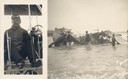
| Date: | 1945 |
|---|---|
| Description: | Marines use an International TD-9 crawler tractor (TracTracTor) and dozer shovel loader to unload supplies on a beach. A ship is in the background. The ori... |
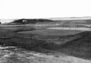
| Date: | |
|---|---|
| Description: | Elevated view of golf links featuring Squaw Island in the distance. |
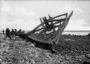
| Date: | |
|---|---|
| Description: | View of part of an old boat frame, presumably from a shipwreck at Point Judith. A group of people are sitting and standing near the frame of the boat on th... |
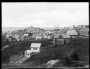
| Date: | 1920 |
|---|---|
| Description: | Elevated view from hill looking down toward buildings in the hills along the coast. |

| Date: | |
|---|---|
| Description: | Elevated view of village homes on the shores of the bay with docked fishing boats in the foreground. Caption reads, "Marblehead, Mass from Rockmere Point." |

| Date: | |
|---|---|
| Description: | Hand-drawn map of the area at the time of Pilgrim landing, drawn by Charles Blaskowikz. Includes commemorative historical notes. |
If you didn't find the material you searched for, our Library Reference Staff can help.
Call our reference desk at 608-264-6535 or email us at: